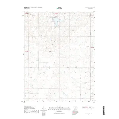
2018 Map of Lake Wabaunsee
USGS Topo · Published 2018About this map
W Br Rock Cr and E Br Rock Cr define the hydrological character of this Wabaunsee County landscape, where the prairie begins to transition toward the more broken terrain of central Kansas. Near the northern margin, residential development is concentrated around Lake Wabaunsee, accessed via Lakeshore Dr and Cedar Cir. Further south, the map reveals a traditional grid of rural thoroughfares with names that hint at local history and topography, such as Mail Route Rd, Hungry Hollow RD, and Mount Pleasant Rd. A notable landmark, Gun Barrel Hill, sits centrally near the intersection of Old K-4 Rd and Flintrock Rd. The southeastern portion of the quadrangle is marked by the winding path of One Hundred and Fiftytwo Mile Cr, a uniquely named waterway flowing toward the Elm Cr drainage.
Find a feature on this map
35 named features on this map. Tap any name to fly to it.
Don’t see what you’re looking for? This feature index may not catch every label — zoom into the map to look around manually.
Map Details
Editions of this 2018 Lake Wabaunsee Map
This is the sole edition of this map. No revisions or reprints were ever made.
Other maps of this area

1885 · Eskridge
USGS Topo · 1:125,000

1889 · Eskridge
USGS Topo · 1:125,000

1894 · Eskridge
USGS Topo · 1:125,000

1955 · Hutchinson
USGS Topo · 1:250,000

1959 · Hutchinson
USGS Topo · 1:250,000
1971 · Admire
USGS Topo · 1:24,000
1971 · Allendorph
USGS Topo · 1:24,000

1971 · Alta Vista SE
USGS Topo · 1:24,000

1971 · Allen
USGS Topo · 1:24,000

1971 · Bushong
USGS Topo · 1:24,000