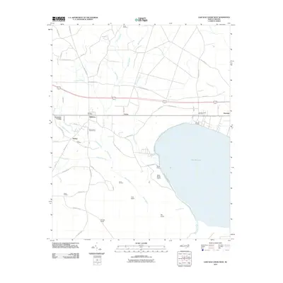
2010 Map of Lake Waccamaw West
USGS Topo · Published 2010About this map
Lake Waccamaw dominates the eastern edge of this landscape, its waters framed by a complex network of wetlands and small settlements in Columbus County. The western shore is defined by Bogue Swamp, a vast hydrologic system that influences the local geography and drainage through features like Alligator Branch and Boggy Branch. Along the northern rail corridor, the historical communities of Hallsboro, Artesia, and Wananish appear, each linked by the transit infrastructure that drove local development. Genealogy researchers will find several family-named landmarks and resting places, including Batten Cemetery, Pierce Cemetery, and Sibbitt Cemetery. The map also details the transition from the structured street grids near the Lake Waccamaw Post Office to the low-lying reaches of Betsy Burgh Island and Big Island, illustrating the delicate balance between habitation and the riverine environment of the Waccamaw River.
Find a feature on this map
59 named features on this map. Tap any name to fly to it.
Don’t see what you’re looking for? This feature index may not catch every label — zoom into the map to look around manually.
Map Details
Editions of this 2010 Lake Waccamaw West Map
This is the sole edition of this map. No revisions or reprints were ever made.
Other maps of this area

1942 · Juniper Creek
USGS Topo · 1:24,000

1943 · Nakina
USGS Topo · 1:24,000

1953 · Florence
USGS Topo · 1:250,000

1954 · Florence
USGS Topo · 1:250,000

1954 · Bolton
USGS Topo · 1:62,500

1955 · Whiteville
USGS Topo · 1:62,500
1986 · Lake Waccamaw East
USGS Topo · 1:24,000
1986 · Council
USGS Topo · 1:24,000

1986 · Whiteville
USGS Topo · 1:100,000
1987 · Clarkton
USGS Topo · 1:24,000