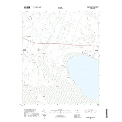
2019 Map of Lake Waccamaw West
USGS Topo · Published 2019About this map
Lake Waccamaw and its northwestern shoreline define this landscape, where the coastal plain of Columbus County transitions from open water to dense wetlands. The settlement pattern follows a clear corridor along the railroad and highway, connecting Hallsboro, Artesia, and Wananish in a nearly linear arrangement. North of the lake, drainage features like Bogue Swamp and Bamberts Bay dominate the terrain, while the lake’s edge is marked by the Cove Canal and The Cove.
Find a feature on this map
80 named features on this map. Tap any name to fly to it.
Don’t see what you’re looking for? This feature index may not catch every label — zoom into the map to look around manually.
Map Details
Editions of this 2019 Lake Waccamaw West Map
This is the sole edition of this map. No revisions or reprints were ever made.
Other maps of this area

1942 · Juniper Creek
USGS Topo · 1:24,000

1943 · Nakina
USGS Topo · 1:24,000

1953 · Florence
USGS Topo · 1:250,000

1954 · Florence
USGS Topo · 1:250,000

1954 · Bolton
USGS Topo · 1:62,500

1955 · Whiteville
USGS Topo · 1:62,500
1986 · Lake Waccamaw East
USGS Topo · 1:24,000
1986 · Council
USGS Topo · 1:24,000

1986 · Whiteville
USGS Topo · 1:100,000
1987 · Clarkton
USGS Topo · 1:24,000