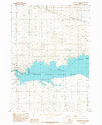
1984 Map of Lake Walcott West
USGS Topo · Published 1984About this map
The Minidoka National Wildlife Refuge dominates this mid-1980s landscape, protecting a massive stretch of the Snake River as it widens into Lake Walcott. The map documents the critical infrastructure of the Minidoka Project, featuring the Power Plant and Spillway that regulate water flow for the region's agricultural network. Irrigation systems are clearly marked, including the Main North Side Canal and the Main South Side Canal, which divert water from the river to transform the arid surroundings. Small ecological and recreational details appear along the water's edge, such as Bird Island, Blue Lake, and a Boat Ramp. This survey provides a precise look at the convergence of three counties—Blaine, Minidoka, and Cassia—at a point defined by hydraulic engineering and wildlife conservation.
Find a feature on this map
14 named features on this map. Tap any name to fly to it.
Don’t see what you’re looking for? This feature index may not catch every label — zoom into the map to look around manually.
Map Details
Editions of this 1984 Lake Walcott West Map
This is the sole edition of this map. No revisions or reprints were ever made.
Other maps of this area

1954 · Pocatello
USGS Topo · 1:250,000

1958 · Pocatello
USGS Topo · 1:250,000

1959 · Lake Walcott
USGS Topo · 1:62,500

1964 · Rupert SE
USGS Topo · 1:24,000

1964 · Acequia
USGS Topo · 1:24,000

1972 · Schodde Well
USGS Topo · 1:24,000

1972 · Minidoka
USGS Topo · 1:24,000

1972 · Max
USGS Topo · 1:24,000
1984 · Lake Walcott SE
USGS Topo · 1:24,000
1984 · Lake Walcott SW
USGS Topo · 1:24,000