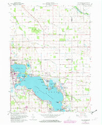
1961 Map of Lake Wawasee
USGS Topo · Published 1982About this map
Lake Wawasee dominates the landscape of this Kosciusko County region, shown here during its mid-century development as a premier lakeside destination. The shoreline is densely populated with distinct communities and resorts, including Syracuse, Pickwick Park, and Enchanted Hills. The mapping records a transition in the local economy and culture, where traditional landmarks like Juday Sch and the Hire Cem sit alongside more modern recreational additions like the Maxwelton Golf Club and the Wawasee State Fish Hatchery. The eastern shore features the prominent Our Lady of the Lake Seminary and the Church of the Little Flower, while the sprawling waters of Conklin Bay and Johnson Bay are defined by named landforms such as Ogden Island and Cedar Point. This survey captures the area just as the Conrail lines and the Baltimore And Ohio Road continued to facilitate the growth of the region's prominent summer colonies.
Find a feature on this map
64 named features on this map. Tap any name to fly to it.
Don’t see what you’re looking for? This feature index may not catch every label — zoom into the map to look around manually.
Map Details
Editions of this 1961 Lake Wawasee Map
Other maps of this area

1950 · Leesburg
USGS Topo · 1:24,000

1950 · North Webster
USGS Topo · 1:24,000

1951 · Milford
USGS Topo · 1:24,000

1951 · Wawasee
USGS Topo · 1:24,000

1951 · Ormas
USGS Topo · 1:24,000

1953 · Fort Wayne
USGS Topo · 1:250,000

1956 · Fort Wayne
USGS Topo · 1:250,000

1956 · Ligonier
USGS Topo · 1:24,000

1959 · Topeka
USGS Topo · 1:24,000

1959 · Millersburg
USGS Topo · 1:24,000