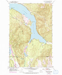
1952 Map of Lake Whatcom
USGS Topo · Published 1973About this map
Lake Whatcom dominates this 1950s landscape, flanked by the steep slopes of Lookout Mountain and Anderson Mountain. The shoreline shows early recreational and industrial development, from the Golf Course and Sunnyside in the north to the State Trout Hatchery and the settlement of Park at the southern terminus. This survey captures a specific moment before further modern expansion, where the primary travel routes like the Lake Whatcom Road and Iowa Heights Rd provided the main links between these lakeside communities.
Find a feature on this map
37 named features on this map. Tap any name to fly to it.
Don’t see what you’re looking for? This feature index may not catch every label — zoom into the map to look around manually.
Map Details
Editions of this 1952 Lake Whatcom Map
4 editions found
Other maps of this area

1906 · Sumas
USGS Topo · 1:62,500

1908 · Sumas
USGS Topo · 1:62,500

1918 · Samish Lake
USGS Topo · 1:62,500

1919 · Van Zandt
USGS Topo · 1:62,500

1921 · Wickersham
USGS Topo · 1:62,500

1951 · Wickersham
USGS Topo · 1:62,500

1951 · Van Zandt
USGS Topo · 1:62,500

1952 · Lake Whatcom
USGS Topo · 1:24,000

1952 · Lawrence
USGS Topo · 1:24,000

1952 · Alger
USGS Topo · 1:24,000