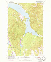
1952 Map of Lake Whatcom
USGS Topo · Published 1974About this map
Lake Whatcom dominates this landscape, its deep waters reaching south toward the border between Whatcom and Skagit counties. The shoreline reflects a transition from early industrial and transportation networks to mid-century recreation, evidenced by the Northern Pacific railroad tracks and the nearby Lake Whatcom Landing Strip near Dutch Harbor. Small settlements like Blue Canyon and Park anchor the southeastern shore, while the State Trout Hatchery points to the early management of the region's aquatic resources.
Find a feature on this map
35 named features on this map. Tap any name to fly to it.
Don’t see what you’re looking for? This feature index may not catch every label — zoom into the map to look around manually.
Map Details
Editions of this 1952 Lake Whatcom Map
4 editions found
Other maps of this area

1906 · Sumas
USGS Topo · 1:62,500

1908 · Sumas
USGS Topo · 1:62,500

1918 · Samish Lake
USGS Topo · 1:62,500

1919 · Van Zandt
USGS Topo · 1:62,500

1921 · Wickersham
USGS Topo · 1:62,500

1951 · Wickersham
USGS Topo · 1:62,500

1951 · Van Zandt
USGS Topo · 1:62,500

1952 · Lake Whatcom
USGS Topo · 1:24,000

1952 · Lawrence
USGS Topo · 1:24,000

1952 · Alger
USGS Topo · 1:24,000