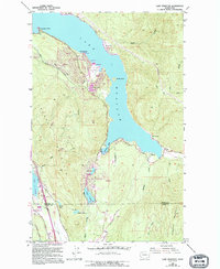
1952 Map of Lake Whatcom
USGS Topo · Published 1994About this map
Lake Whatcom dominates this topographic record, illustrating the residential and recreational development along its southwestern shores and South Bay. The community of Sudden Valley shows a concentrated layout with its Golf Course, Landing Strip, and Sudden Valley Campground, while Sunnyside and Glenhaven appear as established residential hubs. Further south, the landscape shifts toward the smaller waters of Reed Lake, Cain Lake, and Palmer Lake near the Whatcom Co Skagit Co line.
Find a feature on this map
51 named features on this map. Tap any name to fly to it.
Don’t see what you’re looking for? This feature index may not catch every label — zoom into the map to look around manually.
Map Details
Editions of this 1952 Lake Whatcom Map
4 editions found
Other maps of this area

1906 · Sumas
USGS Topo · 1:62,500

1908 · Sumas
USGS Topo · 1:62,500

1918 · Samish Lake
USGS Topo · 1:62,500

1919 · Van Zandt
USGS Topo · 1:62,500

1921 · Wickersham
USGS Topo · 1:62,500

1951 · Wickersham
USGS Topo · 1:62,500

1951 · Van Zandt
USGS Topo · 1:62,500

1952 · Lake Whatcom
USGS Topo · 1:24,000

1952 · Lawrence
USGS Topo · 1:24,000

1952 · Alger
USGS Topo · 1:24,000