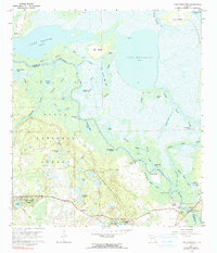
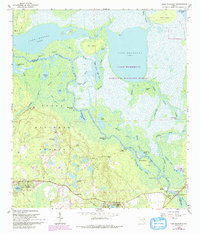
1962 Map of Lake Woodruff
USGS Topo · Published 1990About this map
Ocala National Forest dominates the southwestern quadrant of this Florida landscape, where the dense woodlands meet the intricate wetlands of the St Johns River basin. This 1962 survey reveals a complex hydrological network defined by Lake Dexter and Lake Woodruff, connected by a winding river channel and numerous secondary waterways like the Norris Dead River and St Francis Dead River. Small residential pockets and landings such as Saint Francis, Mosquito Grove, and Dexter Point dot the riverbanks, suggesting a lifestyle deeply tied to the water before significant modern development. In the south, more concentrated settlements like Lake Kathryn Heights, Fullerville, and Forest Hills appear near the Whitehair Bridge, providing a clear record of local geography and road networks in Volusia County during the early 1960s.
Find a feature on this map
63 named features on this map. Tap any name to fly to it.
Don’t see what you’re looking for? This feature index may not catch every label — zoom into the map to look around manually.
Map Details
Editions of this 1962 Lake Woodruff Map
3 editions found
Other maps of this area

1954 · Daytona Beach
USGS Topo · 1:250,000

1955 · Orlando
USGS Topo · 1:250,000

1957 · Orlando
USGS Topo · 1:250,000

1958 · Orlando
USGS Topo · 1:250,000

1958 · Daytona Beach
USGS Topo · 1:250,000

1962 · Orlando
USGS Topo · 1:250,000

1962 · Pine Lakes
USGS Topo · 1:24,000

1962 · Lake Woodruff
USGS Topo · 1:24,000

1964 · Daytona Beach
USGS Topo · 1:250,000
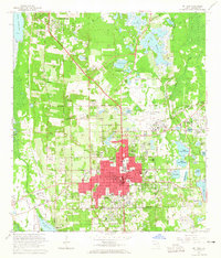
1964 · De Land
USGS Topo · 1:24,000