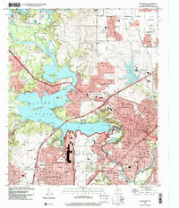
1995 Map of Lake Worth
USGS Topo · Published 2001About this map
The West Fork Trinity River dominates this mid-1990s landscape, feeding into the expansive Lake Worth and supporting a complex infrastructure of aviation and defense. The southern shore is defined by the massive footprint of the Naval Air Station Joint Reserve Base Fort Worth and the adjacent Air Force Plant 4, indicating the area's strategic industrial importance. Surrounding these installations, the residential growth of White Settlement, Westworth Village, and River Oaks is visible, with local life anchored by landmarks like Indian Oaks Ch and the West Side Sch.
Find a feature on this map
66 named features on this map. Tap any name to fly to it.
Don’t see what you’re looking for? This feature index may not catch every label — zoom into the map to look around manually.
Map Details
Editions of this 1995 Lake Worth Map
This is the sole edition of this map. No revisions or reprints were ever made.
Other maps of this area

1891 · Weatherford
USGS Topo · 1:125,000

1893 · Weatherford
USGS Topo · 1:125,000

1894 · Fort Worth
USGS Topo · 1:125,000

1932 · Springtown
USGS Topo · 1:62,500

1954 · Dallas
USGS Topo · 1:250,000

1955 · Haltom City
USGS Topo · 1:24,000

1955 · Avondale
USGS Topo · 1:24,000

1955 · Aledo
USGS Topo · 1:24,000

1955 · Azle
USGS Topo · 1:24,000

1955 · Keller
USGS Topo · 1:24,000