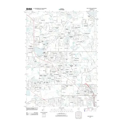
2012 Map of Lake Zurich
USGS Topo · Published 2012About this map
Lake Zurich serves as the central focal point for this suburban landscape, characterized by a dense network of residential subdivisions and local lakes that emerged in the latter half of the 20th century. Named developments like Ancient Oaks, Bridlewoods, and Valentine Manor illustrate the post-war transition from rural Lake County to a mosaic of planned communities. These residential pockets are interspersed with numerous water bodies including Echo Lake, Sylvan Lake, and Diamond Lake, highlighting the area's geography of glacial depressions. Local heritage is preserved at the Lake Zurich Cem and Saint Matthew Lutheran Cem, while larger open spaces like the Lakewood Forest Preserve and Camp Reinberg provide a contrast to the surrounding residential growth. The survey also captures extensive recreational facilities such as the Kemper Lakes Public Golf Course, which occupy significant acreage between the expanding settlements.
Find a feature on this map
305 named features on this map. Tap any name to fly to it.
Don’t see what you’re looking for? This feature index may not catch every label — zoom into the map to look around manually.
Map Details
Editions of this 2012 Lake Zurich Map
This is the sole edition of this map. No revisions or reprints were ever made.
Other maps of this area

1900 · Highwood
USGS Topo · 1:62,500

1906 · Waukegan
USGS Topo · 1:62,500

1908 · Waukegan
USGS Topo · 1:62,500

1920 · Grays Lake
USGS Topo · 1:62,500

1923 · Grays Lake
USGS Topo · 1:62,500

1923 · Barrington
USGS Topo · 1:62,500

1927 · Arlington Heights
USGS Topo · 1:24,000

1928 · Wheeling
USGS Topo · 1:24,000

1935 · Barrington
USGS Topo · 1:62,500
1953 · Arlington Heights
USGS Topo · 1:24,000