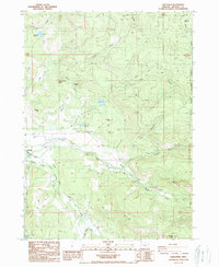
1988 Map of Lakecreek
USGS Topo · Published 1988About this map
Lakecreek serves as a focal point in this 1980s landscape, where the confluence of the North Fork Little Butte Creek and the South Fork Little Butte Creek forms the primary Little Butte Creek. The map documents a complex water management system essential for the region, including the North Fork Canal, South Fork Canal, and the Irrigation District Canal. Several reservoirs, such as Star Lake Reservoir and Gardener Reservoir, are distributed across the hillsides, feeding into the drainage network that defines local land use.
Find a feature on this map
40 named features on this map. Tap any name to fly to it.
Don’t see what you’re looking for? This feature index may not catch every label — zoom into the map to look around manually.
Map Details
Editions of this 1988 Lakecreek Map
This is the sole edition of this map. No revisions or reprints were ever made.
Other maps of this area

1891 · Ashland
USGS Topo · 1:250,000

1893 · Ashland
USGS Topo · 1:250,000

1897 · Ashland
USGS Topo · 1:250,000

1938 · Medford
USGS Topo · 1:125,000

1954 · Butte Falls
USGS Topo · 1:62,500

1954 · Lakecreek
USGS Topo · 1:62,500

1955 · Rustler Peak
USGS Topo · 1:62,500

1955 · Mt. Mc Loughlin
USGS Topo · 1:62,500

1955 · Medford
USGS Topo · 1:250,000

1957 · Medford
USGS Topo · 1:250,000