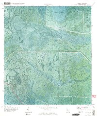
1970 Map of Lakeport
USGS Topo · Published 1976About this map
Fisheating Creek winds through the heart of this Glades County landscape, its course through Sheridan Bend and Cowbone Marsh illustrating the complex natural drainage patterns of south Florida before intensive modern water management. The 1970 orthophotomosaic reveals a transitional period where agricultural infrastructure like the Herbert Hoover Dyke and the Rim Canal coexist with long-standing indigenous and pioneer landmarks. Genealogists and historians will note the proximity of the settlement of Lakeport to the Brighton Indian Reservation, alongside significant archaeological sites including Fort Centre and numerous Indian Mounds. The presence of the Seaboard Coast Line railroad and local thoroughfares like Snakepens Road highlight the transportation network that supported the region's rural economy of hammocks and sloughs.
Find a feature on this map
21 named features on this map. Tap any name to fly to it.
Don’t see what you’re looking for? This feature index may not catch every label — zoom into the map to look around manually.
Map Details
Editions of this 1970 Lakeport Map
3 editions found
Other maps of this area

1953 · Brighton SW
USGS Topo · 1:24,000

1953 · Brighton SE
USGS Topo · 1:24,000

1956 · West Palm Beach
USGS Topo · 1:250,000

1956 · Fort Pierce
USGS Topo · 1:250,000

1957 · West Palm Beach
USGS Topo · 1:250,000

1957 · Venus
USGS Topo · 1:24,000

1958 · Fort Pierce
USGS Topo · 1:250,000

1958 · West Palm Beach
USGS Topo · 1:250,000

1958 · Goodno
USGS Topo · 1:24,000
1958 · Palmdale
USGS Topo · 1:24,000