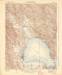
1938 Map of Lakeport
USGS Topo · Published 1938About this map
Lakeport sits as the central hub of this 1930s landscape, bordering the expansive waters of Clear Lake. The survey reveals a settled agricultural and lakeside community, characterized by various named ranches like Querens Ranch and established post offices such as Witter Springs PO. The map provides a detailed view of the era's social infrastructure, including several local schools like Liberty Sch and Glen Eden Sch, alongside the Hartley Cem north of the county seat.
Find a feature on this map
74 named features on this map. Tap any name to fly to it.
Don’t see what you’re looking for? This feature index may not catch every label — zoom into the map to look around manually.
Map Details
Editions of this 1938 Lakeport Map
3 editions found
Other maps of this area

1920 · Ukiah
USGS Topo · 1:62,500

1921 · Kelseyville
USGS Topo · 1:62,500

1922 · Hullville
USGS Topo · 1:62,500

1924 · Bartlett Springs
USGS Topo · 1:62,500

1938 · Lakeport
USGS Topo · 1:62,500

1938 · Hopland
USGS Topo · 1:62,500

1942 · Bartlett Springs
USGS Topo · 1:62,500

1943 · Pomo
USGS Topo · 1:62,500

1943 · Kelseyville
USGS Topo · 1:62,500

1943 · Hopland
USGS Topo · 1:62,500