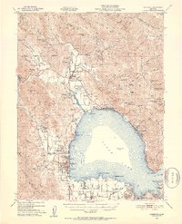
1951 Map of Lakeport
USGS Topo · Published 1953About this map
Clear Lake dominates the central landscape of this 1950s survey, its northern reaches framed by a network of rancherias and small lakeside settlements. The town of Lakeport serves as the focal point on the western shore, positioned near the Lake County Fairground and Lakeside Hospital. To the north, the geography reflects a complex cultural history, marked by the Bloody Island Massacre Historic Marker near Upper Lake and several indigenous land areas including the Upper Lake Rancherias, Robinson Rancheria, and Scotts Valley Rancheria.
Find a feature on this map
115 named features on this map. Tap any name to fly to it.
Don’t see what you’re looking for? This feature index may not catch every label — zoom into the map to look around manually.
Map Details
Editions of this 1951 Lakeport Map
2 editions found

Other maps of this area

1920 · Ukiah
USGS Topo · 1:62,500

1921 · Kelseyville
USGS Topo · 1:62,500

1922 · Hullville
USGS Topo · 1:62,500

1924 · Bartlett Springs
USGS Topo · 1:62,500

1938 · Lakeport
USGS Topo · 1:62,500

1938 · Hopland
USGS Topo · 1:62,500

1942 · Bartlett Springs
USGS Topo · 1:62,500

1943 · Pomo
USGS Topo · 1:62,500

1943 · Kelseyville
USGS Topo · 1:62,500

1943 · Hopland
USGS Topo · 1:62,500