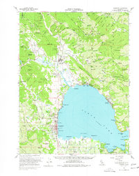
1958 Map of Lakeport
USGS Topo · Published 1977About this map
Lakeport and the northern shores of Clear Lake anchor this mid-century topographic survey, showing a landscape defined by waterfront resorts and agricultural settlements. The map documents significant cultural sites including the Upper Lake (Pomo) Rancheria and the Bloody Island Massacre Historical Marker near the Slough. Along the western foothills, the legacy of California’s mineral spring era is visible at Saratoga Springs and Witter Springs PO. The eastern shoreline is dotted with vacation developments like Nice and Lucerne, while the southern portion of the quadrangle shows the productive lands of Big Valley Rancheria near Finley. High peaks such as Pine Mtn and White Rock overlook the basin, illustrating the transition from the lake's aquatic economy to the timber and grazing lands of the surrounding mountains.
Find a feature on this map
167 named features on this map. Tap any name to fly to it.
Don’t see what you’re looking for? This feature index may not catch every label — zoom into the map to look around manually.
Map Details
Editions of this 1958 Lakeport Map
3 editions found
Other maps of this area

1920 · Ukiah
USGS Topo · 1:62,500

1921 · Kelseyville
USGS Topo · 1:62,500

1922 · Hullville
USGS Topo · 1:62,500

1924 · Bartlett Springs
USGS Topo · 1:62,500

1938 · Lakeport
USGS Topo · 1:62,500

1938 · Hopland
USGS Topo · 1:62,500

1942 · Bartlett Springs
USGS Topo · 1:62,500

1943 · Pomo
USGS Topo · 1:62,500

1943 · Kelseyville
USGS Topo · 1:62,500

1943 · Hopland
USGS Topo · 1:62,500