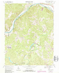
1969 Map of Lakeside Village
USGS Topo · Published 1987About this map
The James River corridor defines the northern reach of this quadrangle, where the CSX rail line follows the riverbank past Boatwrights Island and Elk Island. Inland, the landscape transition into the managed timberlands of the Cumberland State Forest, a terrain of narrow ridges and creek bottoms. Settlement is dispersed among small rural hubs such as Lakeside Village, Duncans Store, and Trenton Mills, often clustered near old country churches like Fork of Willis Ch and Oakwood Ch.
Find a feature on this map
39 named features on this map. Tap any name to fly to it.
Don’t see what you’re looking for? This feature index may not catch every label — zoom into the map to look around manually.
Map Details
Editions of this 1969 Lakeside Village Map
2 editions found
Other maps of this area

1891 · Palmyra
USGS Topo · 1:125,000

1895 · Palmyra
USGS Topo · 1:125,000

1897 · Palmyra
USGS Topo · 1:125,000

1943 · Scottsville
USGS Topo · 1:62,500

1946 · Scottsville
USGS Topo · 1:62,500

1947 · Roanoke
USGS Topo · 1:250,000

1950 · Dillwyn
USGS Topo · 1:62,500

1958 · Dillwyn
USGS Topo · 1:62,500

1959 · Roanoke
USGS Topo · 1:250,000

1960 · Columbia
USGS Topo · 1:62,500