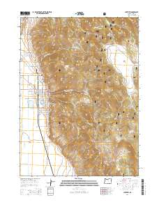
2014 Map of Lakeview
USGS Topo · Published 2014About this map
Lakeview serves as the focal point of this high-altitude landscape, situated at the junction of the Klamath Falls-Lakeview Hwy and Us-395. The town's layout is meticulously detailed, showing a residential grid that transitions into the steep slopes of Black Cap and the surrounding rimrock. Local history and genealogy are anchored by the Independent Order of Odd Fellows Cem and Sunset Cem located near the town's northern edge. To the north, the geothermal feature Hunters Hot Springs stands near the intersection of the Warner Hwy and Fremont Hwy. The surrounding Fremont National Forest dominates the topography, characterized by deep incisions like Warner Canyon, Hammersley Canyon, and Deadman Canyon. The map reveals a network of forest development roads reaching into high-elevation meadows and springs, including Ski Lodge Spring and Camas Prairie, illustrating the area's dual character as both a mountain hub and a gateway to the high desert wilderness.
Find a feature on this map
70 named features on this map. Tap any name to fly to it.
Don’t see what you’re looking for? This feature index may not catch every label — zoom into the map to look around manually.
Map Details
Editions of this 2014 Lakeview Map
This is the sole edition of this map. No revisions or reprints were ever made.
Other maps of this area

1955 · Klamath Falls
USGS Topo · 1:250,000

1958 · Klamath Falls
USGS Topo · 1:250,000

1964 · Lakeview NE
USGS Topo · 1:24,000

1964 · Crooked Creek Valley
USGS Topo · 1:24,000

1964 · Lakeview SW
USGS Topo · 1:24,000

1964 · Lakeview NW
USGS Topo · 1:24,000
1964 · Crane Creek
USGS Topo · 1:24,000

1964 · Big Baldy
USGS Topo · 1:24,000

1968 · Crook Peak
USGS Topo · 1:24,000
1968 · Horse Prairie
USGS Topo · 1:24,000