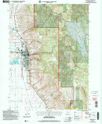
2004 Map of Lakeview
USGS Topo · Published 2007About this map
Lakeview serves as the focal point of this survey, functioning as the gateway to the high desert and timbered slopes of the Fremont National Forest. As the county seat, the town's administrative role is evident through the presence of the Courthouse, Hospital, and the Fremont-Winema Hdqtrs. The map illustrates a landscape where municipal utility and recreation meet the edge of the wilderness, from the Sewage Disposal Ponds and the County Fairgrounds to the Warner Canyon Ski Area just to the northeast. To the north, Hunters Hot Sprs marks a distinct geothermal feature of the region. The eastern terrain rises sharply toward Black Cap and into the high plateau of Camas Prairie, where an Underground Aqueduct and numerous Springs hint at the critical management of water in this arid environment.
Find a feature on this map
39 named features on this map. Tap any name to fly to it.
Don’t see what you’re looking for? This feature index may not catch every label — zoom into the map to look around manually.
Map Details
Editions of this 2004 Lakeview Map
This is the sole edition of this map. No revisions or reprints were ever made.
Other maps of this area

1955 · Klamath Falls
USGS Topo · 1:250,000

1958 · Klamath Falls
USGS Topo · 1:250,000

1964 · Lakeview NE
USGS Topo · 1:24,000

1964 · Crooked Creek Valley
USGS Topo · 1:24,000

1964 · Lakeview SW
USGS Topo · 1:24,000

1964 · Lakeview NW
USGS Topo · 1:24,000
1964 · Crane Creek
USGS Topo · 1:24,000

1964 · Big Baldy
USGS Topo · 1:24,000

1968 · Crook Peak
USGS Topo · 1:24,000
1968 · Horse Prairie
USGS Topo · 1:24,000