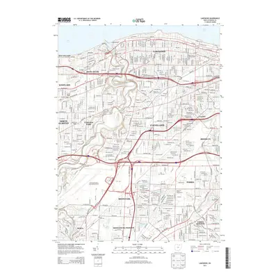
2013 Map of Lakewood
USGS Topo · Published 2013About this map
The Rocky River carves a deep valley through the suburban landscape west of Cleveland, creating a natural divider between communities like Rocky River and Lakewood. This 2013 survey illustrates the dense residential and industrial grid of the West Side, anchored by major transport hubs and institutional landmarks. The southern portion of the map is dominated by the sprawling footprint of the Cleveland-Hopkins International Airport and the surrounding industrial corridors along Industrial Pkwy.
Find a feature on this map
73 named features on this map. Tap any name to fly to it.
Don’t see what you’re looking for? This feature index may not catch every label — zoom into the map to look around manually.
Map Details
Editions of this 2013 Lakewood Map
This is the sole edition of this map. No revisions or reprints were ever made.
Other maps of this area

1901 · Euclid
USGS Topo · 1:62,500

1902 · Berea
USGS Topo · 1:62,500

1903 · Cleveland
USGS Topo · 1:62,500

1903 · Euclid
USGS Topo · 1:62,500

1904 · Berea
USGS Topo · 1:62,500

1950 · Cleveland
USGS Topo · 1:250,000

1953 · West View
USGS Topo · 1:24,000

1953 · Broadview Heights
USGS Topo · 1:24,000

1953 · Berea
USGS Topo · 1:24,000
1953 · Cleveland South
USGS Topo · 1:24,000