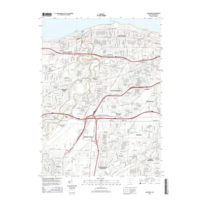
2016 Map of Lakewood
USGS Topo · Published 2016About this map
Lake Erie defines the northern boundary of this urbanized corridor, where the residential grids of Lakewood and Rocky River meet at the winding course of the Rocky River. The landscape is shaped by glacial geology, evidenced by the prominent elevations of North Ridge, Center Ridge, and Butternut Ridge, which historically dictated the paths of major thoroughfares like Detroit Rd. To the south, the industrial and logistical character of the region is centered around Cleveland-Hopkins International Airport and the sprawling rail infrastructure at Short Line Junction.
Find a feature on this map
52 named features on this map. Tap any name to fly to it.
Don’t see what you’re looking for? This feature index may not catch every label — zoom into the map to look around manually.
Map Details
Editions of this 2016 Lakewood Map
This is the sole edition of this map. No revisions or reprints were ever made.
Other maps of this area

1901 · Euclid
USGS Topo · 1:62,500

1902 · Berea
USGS Topo · 1:62,500

1903 · Cleveland
USGS Topo · 1:62,500

1903 · Euclid
USGS Topo · 1:62,500

1904 · Berea
USGS Topo · 1:62,500

1950 · Cleveland
USGS Topo · 1:250,000

1953 · West View
USGS Topo · 1:24,000

1953 · Broadview Heights
USGS Topo · 1:24,000

1953 · Berea
USGS Topo · 1:24,000
1953 · Cleveland South
USGS Topo · 1:24,000