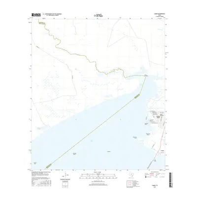
2016 Map of Lamar
USGS Topo · Published 2016About this map
Lamar Peninsula separates the vast waters of Copano Bay from the surrounding wetlands and estuaries of the Texas Gulf Coast. This coastal landscape is defined by its intricate network of marine features, including submerged hazards and fishing grounds such as Copano Reef, Pier Reef, and Lap Reef Bank. The community of Holiday Beach occupies the northern reach of the peninsula, characterized by residential streets like Northview Dr and Mesquite Tree Dr, while the historic settlement of Lamar anchors the southern tip near Park Rd 13. The geography reflects the transition from open bay to salt marshes at Turtle Pen Flats and the winding course of Copano Cr, which marks the boundary between Aransas and Refugio counties. Modern transit is facilitated by the Lyndon B Johnson Cswy, connecting these coastal communities across the water to the south.
Find a feature on this map
38 named features on this map. Tap any name to fly to it.
Don’t see what you’re looking for? This feature index may not catch every label — zoom into the map to look around manually.
Map Details
Editions of this 2016 Lamar Map
This is the sole edition of this map. No revisions or reprints were ever made.
Other maps of this area

1952 · St. Charles Bay SW
USGS Topo · 1:24,000

1952 · St. Charles Bay
USGS Topo · 1:24,000

1952 · Tivoli SW
USGS Topo · 1:24,000

1953 · Beeville
USGS Topo · 1:250,000

1954 · Rockport
USGS Topo · 1:62,500

1954 · Vidaurri
USGS Topo · 1:62,500

1956 · Beeville
USGS Topo · 1:250,000

1960 · Beeville
USGS Topo · 1:250,000
1978 · Twin Mott Lake
USGS Topo · 1:24,000
1979 · Mission Bay
USGS Topo · 1:24,000