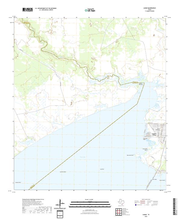
2022 Map of Lamar
USGS Topo · Published 2022About this map
The coastal waters of Copano Bay dominate this coastal landscape, where the shallow flats and reefs meet the Lamar Peninsula. The residential development at Holiday Beach is clearly defined, with a grid of streets like Kingfish Dr and Sailfish Dr reflecting the area's identity as a seaside community. To the south, Goose Island and the Pier Reef mark the transition toward the deeper waters, while the Lyndon B Johnson Cswy provides the primary southern passage across the bay.
Find a feature on this map
34 named features on this map. Tap any name to fly to it.
Don’t see what you’re looking for? This feature index may not catch every label — zoom into the map to look around manually.
Map Details
Editions of this 2022 Lamar Map
This is the sole edition of this map. No revisions or reprints were ever made.
Other maps of this area

1952 · St. Charles Bay SW
USGS Topo · 1:24,000

1952 · St. Charles Bay
USGS Topo · 1:24,000

1952 · Tivoli SW
USGS Topo · 1:24,000

1953 · Beeville
USGS Topo · 1:250,000

1954 · Rockport
USGS Topo · 1:62,500

1954 · Vidaurri
USGS Topo · 1:62,500

1956 · Beeville
USGS Topo · 1:250,000

1960 · Beeville
USGS Topo · 1:250,000
1978 · Twin Mott Lake
USGS Topo · 1:24,000
1979 · Mission Bay
USGS Topo · 1:24,000