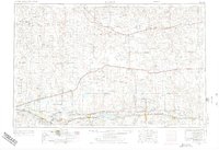
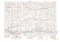
1954 Map of Lamar
USGS Topo · Published 1976About this map
The Arkansas River valley serves as the primary artery for settlement and commerce across this mid-century landscape, anchored by the significant presence of the John Martin Reservoir. The region is defined by its rail infrastructure, with the Atchison Topeka and Santa Fe following the river through La Junta and Lamar, while the Missouri Pacific traverses the northern plains through Eads and Sheridan Lake. This infrastructure supported a network of rural hubs and institutions, such as the Fort Lyon Veteran Hospital and numerous local education centers like May Valley School and Hillcrest School. Beyond the irrigated river corridor, the terrain transitions into the Big Sand Hills, where smaller ranching outposts like Pumpkin Center and Karval are linked by U S 40.
Find a feature on this map
69 named features on this map. Tap any name to fly to it.
Don’t see what you’re looking for? This feature index may not catch every label — zoom into the map to look around manually.
Map Details
Editions of this 1954 Lamar Map
3 editions found

Other maps of this area

1889 · Sanborn
USGS Topo · 1:125,000

1890 · Granada
USGS Topo · 1:125,000

1891 · Sanborn
USGS Topo · 1:125,000

1891 · Catlin
USGS Topo · 1:125,000

1891 · Arroyo
USGS Topo · 1:125,000

1891 · Albany
USGS Topo · 1:125,000

1891 · Kit Carson
USGS Topo · 1:125,000

1891 · Higbee
USGS Topo · 1:125,000

1891 · Las Animas
USGS Topo · 1:125,000

1891 · Timpas
USGS Topo · 1:125,000