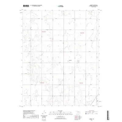
2018 Map of Lambert
USGS Topo · Published 2018About this map
Lambert and the neighboring community of Yewed occupy a central position in this Alfalfa County landscape, where the prairie is etched by seasonal watercourses and a strict grid of section roads. The terrain is defined by the drainage patterns of Cottonwood Cr, which meanders through the central sections, and Lambert Cr to the east. These waterways break the geometric regularity of the agricultural plats, creating a varied topography amidst the township lines of T26N and T25N. For those tracing family histories in the region, the Auburn Cem and Maple Grove Cem provide specific points of reference for early 20th-century settlement. The map reflects a rural economy dependent on well-maintained corridors like Grady Rd and Custer Rd, which connect the scattered farmsteads and small crossroads communities characteristic of Oklahoma's northwestern plains.
Find a feature on this map
23 named features on this map. Tap any name to fly to it.
Don’t see what you’re looking for? This feature index may not catch every label — zoom into the map to look around manually.
Map Details
Editions of this 2018 Lambert Map
This is the sole edition of this map. No revisions or reprints were ever made.
Other maps of this area

1955 · Woodward
USGS Topo · 1:250,000

1958 · Woodward
USGS Topo · 1:250,000

1968 · Carmen
USGS Topo · 1:24,000

1969 · Dacoma
USGS Topo · 1:24,000

1969 · Lambert
USGS Topo · 1:24,000

1969 · Alva SE
USGS Topo · 1:24,000

1969 · Helena
USGS Topo · 1:24,000

1969 · Cherokee North
USGS Topo · 1:24,000

1969 · Ingersoll
USGS Topo · 1:24,000
1969 · Dacoma SE
USGS Topo · 1:24,000