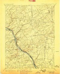
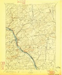
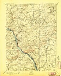
1894 Map of Lambertville
USGS Topo · Published 1898About this map
The Delaware River corridor serves as the industrial and transportation backbone of this region during the late 19th century, featuring a complex network of waterways and rail lines. The twin settlements of Lambertville and New Hope anchor the center of the sheet, where the Delaware and Raritan Canal and the Pennsylvania Canal parallel the riverbanks. This era captures the height of the canal system's relevance alongside the expanding Pennsylvania Railroad Belvidere Division, which follows the eastern shore through Stockton and Brookville.
Find a feature on this map
99 named features on this map. Tap any name to fly to it.
Don’t see what you’re looking for? This feature index may not catch every label — zoom into the map to look around manually.
Map Details
Editions of this 1894 Lambertville Map
4 editions found

Other maps of this area

1888 · Bordentown
USGS Topo · 1:62,500

1888 · Princeton
USGS Topo · 1:62,500

1890 · Easton
USGS Topo · 1:62,500

1890 · High Bridge
USGS Topo · 1:62,500

1890 · Lambertville
USGS Topo · 1:62,500

1890 · Doylestown
USGS Topo · 1:62,500

1890 · Burlington
USGS Topo · 1:62,500

1891 · Somerville
USGS Topo · 1:62,500

1891 · Easton
USGS Topo · 1:62,500

1891 · Lambertville
USGS Topo · 1:62,500
Featured Places
- Hillsborough Township, NJ
- Ewing Township, NJ
- Lawrence Township, NJ
- Lower Makefield Township, PA
- Raritan Township, NJ