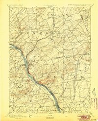
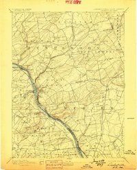
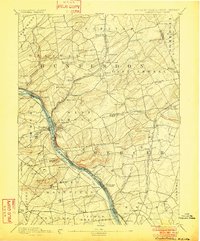
1894 Map of Lambertville
USGS Topo · Published 1905About this map
Delaware River serves as the central artery of this late-19th-century landscape, flanked by significant industrial infrastructure including the Pennsylvania Canal on the west bank and the Delaware and Raritan Canal Feeder on the east. The river crossing at Lambertville and New Hope anchors the region, while the Pennsylvania Railroad Belvidere Division follows the river's path, highlighting the transition from canal-based to rail-based transport. To the south, Washington Crossing marks a historically significant bend in the river near Bowman Hill. The terrain rises into Jericho Mountain and the rolling uplands of Hunterdon and Mercer counties, where a dense network of crossroad settlements like Larison Corner, Muirheads, and Ringoes suggests a well-established agricultural economy. This survey documents the complex water and rail networks that fueled the development of the river valley before the modern highway era redefined these historic corridors.
Find a feature on this map
99 named features on this map. Tap any name to fly to it.
Don’t see what you’re looking for? This feature index may not catch every label — zoom into the map to look around manually.
Map Details
Editions of this 1894 Lambertville Map
4 editions found

Other maps of this area

1888 · Bordentown
USGS Topo · 1:62,500

1888 · Princeton
USGS Topo · 1:62,500

1890 · Easton
USGS Topo · 1:62,500

1890 · High Bridge
USGS Topo · 1:62,500

1890 · Lambertville
USGS Topo · 1:62,500

1890 · Doylestown
USGS Topo · 1:62,500

1890 · Burlington
USGS Topo · 1:62,500

1891 · Somerville
USGS Topo · 1:62,500

1891 · Easton
USGS Topo · 1:62,500

1891 · Lambertville
USGS Topo · 1:62,500
Featured Places
- Hillsborough Township, NJ
- Ewing Township, NJ
- Lawrence Township, NJ
- Lower Makefield Township, PA
- Raritan Township, NJ