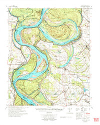
1977 Map of Lamont
USGS Topo · Published 1977About this map
The Mississippi River meanders through this landscape on the border of Arkansas and Mississippi, defining a terrain shaped by dynamic hydrology and decades of engineering. Massive oxbows like Lake Whittington and Chicot Lake tell the story of the river's shifting course, while the Caulk Cut-Off (1937) and Ashbrook Cut-Off 1935 demonstrate mid-century efforts to stabilize and shorten the channel. On the Arkansas bank, Arkansas City sits behind a network of dikes and revetments, while the Mississippi side is characterized by smaller agricultural settlements like Scott, Benoit, and Lamont.
Find a feature on this map
98 named features on this map. Tap any name to fly to it.
Don’t see what you’re looking for? This feature index may not catch every label — zoom into the map to look around manually.
Map Details
Editions of this 1977 Lamont Map
2 editions found
Other maps of this area

1933 · Lamont
USGS Topo · 1:62,500

1935 · Red Fork
USGS Topo · 1:62,500

1936 · McGehee
USGS Topo · 1:62,500

1936 · Lake Village
USGS Topo · 1:62,500

1937 · McGehee
USGS Topo · 1:62,500

1939 · Pace
USGS Topo · 1:62,500

1939 · Big Island
USGS Topo · 1:62,500

1939 · Refuge
USGS Topo · 1:62,500

1939 · Lamont
USGS Topo · 1:62,500

1939 · Tralake
USGS Topo · 1:62,500