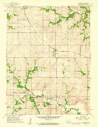
1961 Map of Lancaster
USGS Topo · Published 1962About this map
Lancaster stands as a central rail hub on this 1961 survey, where the Missouri Pacific line bisects the township. The landscape is defined by the headwaters and meandering drainage of several significant watercourses, including Grasshopper Creek in the northwest and Stranger Creek to the south. This era shows a settled agricultural community established around small villages like Monrovia and Farmington. For family historians, the sheet is particularly valuable for its pinpointing of rural landmarks such as Old Huron Cem, Maple Grove Cem, and the Monrovia Cem. Education in the outlying districts is represented by the Shannon Sch, situated east of the main Lancaster townsite. The intricate contour work illustrates the dissected upland terrain between Independence Creek and the various forks of the Stranger Creek system, reflecting the traditional land use patterns of northeastern Kansas before modern regional consolidation.
Find a feature on this map
20 named features on this map. Tap any name to fly to it.
Don’t see what you’re looking for? This feature index may not catch every label — zoom into the map to look around manually.
Map Details
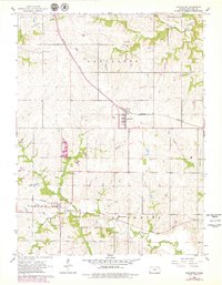
Editions of this 1961 Lancaster Map
2 editions found
Other maps of this area

1885 · Atchison
USGS Topo · 1:125,000

1886 · Oskaloosa
USGS Topo · 1:125,000

1888 · Oskaloosa
USGS Topo · 1:125,000

1888 · Atchison
USGS Topo · 1:125,000

1893 · Atchison
USGS Topo · 1:125,000

1894 · Oskaloosa
USGS Topo · 1:125,000

1926 · Atchison
USGS Topo · 1:62,500

1950 · Kansas City
USGS Topo · 1:250,000

1954 · Kansas City
USGS Topo · 1:250,000

1956 · Kansas City
USGS Topo · 1:250,000