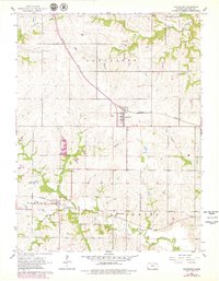
1961 Map of Lancaster
USGS Topo · Published 1979About this map
The agrarian landscape of Atchison County is defined here by the headwaters of several major regional drainage systems, including Grasshopper Creek and Stranger Creek. The area’s transport economy is centered on the Missouri Pacific railroad, which cuts a straight path through the township of Lancaster, linking the small rail-stop communities of Monrovia and Farmington. This 1961 field-checked survey provides a clear view of the rural infrastructure of the mid-20th century, where local cemeteries like Old Huron Cem, Maple Grove Cem, and Monrovia Cem serve as critical markers for genealogical research. The map also captures a significant network of field lines and property boundaries, many of which were updated via aerial photography in the late 1970s. The dense concentration of creek forks, such as North Fork Stranger Creek and Little Stranger Creek, illustrates the complex topography that dictated farm placement and road development in this part of Kansas.
Find a feature on this map
17 named features on this map. Tap any name to fly to it.
Don’t see what you’re looking for? This feature index may not catch every label — zoom into the map to look around manually.
Map Details
Editions of this 1961 Lancaster Map
2 editions found
Other maps of this area

1885 · Atchison
USGS Topo · 1:125,000

1886 · Oskaloosa
USGS Topo · 1:125,000

1888 · Oskaloosa
USGS Topo · 1:125,000

1888 · Atchison
USGS Topo · 1:125,000

1893 · Atchison
USGS Topo · 1:125,000

1894 · Oskaloosa
USGS Topo · 1:125,000

1926 · Atchison
USGS Topo · 1:62,500

1950 · Kansas City
USGS Topo · 1:250,000

1954 · Kansas City
USGS Topo · 1:250,000

1956 · Kansas City
USGS Topo · 1:250,000