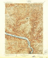
1908 Map of Lancaster
USGS Topo · Published 1939About this map
The Mississippi River valley dominates this turn-of-the-century survey, revealing a landscape defined by deep river gorges and the busy transit corridors of southwest Wisconsin and northeast Iowa. Steamboat and rail traffic converge at riverside points like Cassville, Potosi Sta, and Spechts Ferry, where the Chicago Milwaukee and St Paul RR and other lines trace the water's edge. Inland, the seat of Lancaster serves as a hub for upland agricultural and mining settlements including British Hollow and Beetown. The topography is marked by significant landmarks like Sinsinawa Mound and Eagle Point, rising above the intricate drainage networks of the Platte River and Grant River. This map captures the region before modern highway development, highlighting the reliance on local rail spurs such as the Chicago and Northwestern RR to connect remote townships like Patch Grove and Ellenboro to the larger river economy.
Find a feature on this map
120 named features on this map. Tap any name to fly to it.
Don’t see what you’re looking for? This feature index may not catch every label — zoom into the map to look around manually.
Map Details
Editions of this 1908 Lancaster Map
5 editions found
Other maps of this area

1900 · Anamosa
USGS Topo · 1:125,000

1900 · Lancaster
USGS Topo · 1:125,000

1901 · Peosta
USGS Topo · 1:125,000

1902 · Mineral Point
USGS Topo · 1:125,000

1902 · Elkader
USGS Topo · 1:125,000

1903 · Waukon
USGS Topo · 1:125,000

1904 · Lancaster
USGS Topo · 1:125,000

1905 · Richland Center
USGS Topo · 1:125,000

1908 · Lancaster
USGS Topo · 1:125,000

1911 · Galena
USGS Topo · 1:62,500