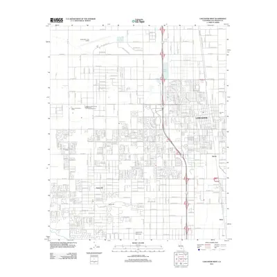
2012 Map of Lancaster West
USGS Topo · Published 2012About this map
Lancaster and Quartz Hill anchor this portion of the Antelope Valley during a period of significant suburban expansion in Los Angeles County. The urban landscape is defined by an extensive grid of numbered avenues, from W Avenue F in the north to W Avenue N at the southern edge, illustrating the systematic development of the high desert. Significant infrastructure includes the General Wm J Fox Airfield and institutional sites like the Mira Loma Detention Facility. Local history is preserved at the Lancaster Cem, while smaller residential pockets like Sunrise and Denis appear on the fringes of the primary townships. The terrain is largely flat, punctuated by the seasonal Amargosa Cr and the equestrian grounds of the Antelope Valley Desert Riders Arena, reflecting a community that maintains its desert-living identity alongside modern infrastructure.
Find a feature on this map
76 named features on this map. Tap any name to fly to it.
Don’t see what you’re looking for? This feature index may not catch every label — zoom into the map to look around manually.
Map Details
Editions of this 2012 Lancaster West Map
This is the sole edition of this map. No revisions or reprints were ever made.
Other maps of this area

1915 · Elizabeth Lake
USGS Topo · 1:125,000

1917 · Elizabeth Lake
USGS Topo · 1:125,000

1930 · Oban
USGS Topo · 1:24,000

1930 · Lancaster
USGS Topo · 1:24,000

1931 · Del Sur
USGS Topo · 1:24,000

1931 · Esperanza School
USGS Topo · 1:24,000

1933 · Lancaster
USGS Topo · 1:24,000

1933 · Oban
USGS Topo · 1:24,000

1934 · Esperanza School
USGS Topo · 1:24,000
1936 · Del Sur
USGS Topo · 1:24,000