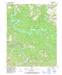
1992 Map of Lancer
USGS Topo · Published 1992About this map
Dewey Lake dominates this portion of Floyd County, its winding waters controlled by the Dewey Dam and surrounded by the Dewey Lake State Wildlife Management Area. Along the western shore, Jenny Wiley State Resort Park provides a recreational focal point, while the Levisa Fork cuts a parallel path to the south, bordered by the CSX Transportation railroad. The map records a landscape where industry and community intersect, featuring numerous mines and drill holes alongside established rural settlements.
Find a feature on this map
71 named features on this map. Tap any name to fly to it.
Don’t see what you’re looking for? This feature index may not catch every label — zoom into the map to look around manually.
Map Details
Editions of this 1992 Lancer Map
This is the sole edition of this map. No revisions or reprints were ever made.
Other maps of this area

1886 · Prestonsburg
USGS Topo · 1:125,000

1892 · Prestonsburg
USGS Topo · 1:125,000

1914 · Laynesville
USGS Topo · 1:48,000

1914 · Inez
USGS Topo · 1:48,000

1915 · Paintsville
USGS Topo · 1:48,000

1915 · Prestonsburg
USGS Topo · 1:62,500

1916 · Harold
USGS Topo · 1:62,500

1916 · Inez
USGS Topo · 1:62,500

1917 · Paintsville
USGS Topo · 1:62,500

1918 · Prestonsburg
USGS Topo · 1:62,500