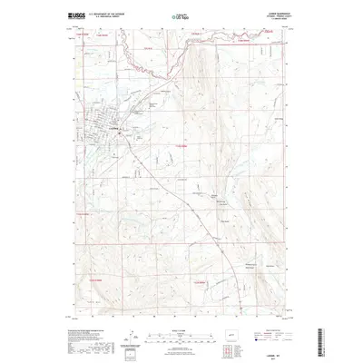
2021 Map of Lander
USGS Topo · Published 2021About this map
Lander serves as a central hub where the forks of the Popo Agie River converge, creating a landscape defined by an intricate network of irrigation ditches and mountain-shadowed valleys. The town's civic importance is anchored by the Fremont County Courthouse and the Central Wyoming College Lander Campus, while its agricultural roots are evident in the complex water management system featuring the Nicol Table Mountain Ditch, Sioux Ditch, and Taylor Ditch. To the east and south, the terrain rises sharply toward Blue Ridge and Table Mtn, illustrating the transition from the river basins to the high plains. Local history is preserved at the Mount Hope Cem and the Wyoming State Training School Cem, while aviation history is represented by Hunt Field. The map meticulously details the surrounding settlements like Lyons Valley, illustrating how early 21st-century Wyoming communities integrated water rights and rugged topography.
Find a feature on this map
135 named features on this map. Tap any name to fly to it.
Don’t see what you’re looking for? This feature index may not catch every label — zoom into the map to look around manually.
Map Details
Editions of this 2021 Lander Map
This is the sole edition of this map. No revisions or reprints were ever made.
Other maps of this area

1952 · Hudson
USGS Topo · 1:24,000

1952 · Ray Lake
USGS Topo · 1:24,000

1952 · Lander SE
USGS Topo · 1:24,000

1952 · Lander
USGS Topo · 1:24,000

1952 · Lander NW
USGS Topo · 1:24,000

1953 · Fossil Hill
USGS Topo · 1:24,000

1953 · Weiser Pass
USGS Topo · 1:24,000

1953 · Mount Arter SE
USGS Topo · 1:24,000

1954 · Wolf Point
USGS Topo · 1:24,000

1955 · Lander
USGS Topo · 1:250,000