
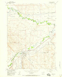
1952 Map of Lander
USGS Topo · Published 1954About this map
Lander serves as the focal point of this mid-century survey, situated at the confluence where the North Fork Popo Agie River and Middle Popo Agie River meet. The town's infrastructure is clearly visible, including the Chicago and North Western rail line terminating at the Freight Depot and the State Training School located to the northeast. To the north, the Wind River Indian Reservation Boundary follows the winding path of the Wind River, separating the municipal limits from reservation lands.
Find a feature on this map
53 named features on this map. Tap any name to fly to it.
Don’t see what you’re looking for? This feature index may not catch every label — zoom into the map to look around manually.
Map Details
Editions of this 1952 Lander Map
This is the sole edition of this map. No revisions or reprints were ever made.
Other maps of this area

1952 · Hudson
USGS Topo · 1:24,000

1952 · Ray Lake
USGS Topo · 1:24,000

1952 · Lander SE
USGS Topo · 1:24,000

1952 · Lander NW
USGS Topo · 1:24,000

1953 · Fossil Hill
USGS Topo · 1:24,000

1953 · Weiser Pass
USGS Topo · 1:24,000

1953 · Mount Arter SE
USGS Topo · 1:24,000

1954 · Wolf Point
USGS Topo · 1:24,000

1955 · Lander
USGS Topo · 1:250,000
1957 · Hudson
USGS Topo · 1:24,000