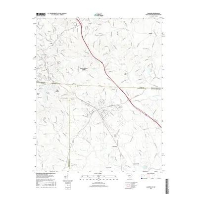
2017 Map of Landrum
USGS Topo · Published 2017About this map
Landrum serves as the central hub of this 2017 survey, situated right at the state line where the Piedmont begins its ascent into the Blue Ridge foothills. The landscape is defined by the drainage systems of the N Pacolet River and North Pacolet River, which carve through the terrain near settlements like Tryon and Columbus. Local heritage is preserved in sites such as Good Shepherd Cem and Oak Grove Cem, while the recreational importance of Lake Lanier is evident along the Greenville Co border. Significant transit corridors and small-town footprints, including Campobello and Ingleside, illustrate the modern settlement pattern of the Spartanburg and Polk County region. The map also captures distinctive local landmarks like Burnt Chimney Corner and the crossing at Guthrie Bridge over the S Pacolet River.
Find a feature on this map
231 named features on this map. Tap any name to fly to it.
Don’t see what you’re looking for? This feature index may not catch every label — zoom into the map to look around manually.
Map Details
Editions of this 2017 Landrum Map
This is the sole edition of this map. No revisions or reprints were ever made.
Other maps of this area

1907 · Saluda
USGS Topo · 1:125,000

1935 · Fishtop
USGS Topo · 1:24,000

1946 · Cliffield Mtn
USGS Topo · 1:24,000

1947 · Cliffield Mtn.
USGS Topo · 1:24,000

1955 · Knoxville
USGS Topo · 1:250,000

1957 · Knoxville
USGS Topo · 1:250,000

1959 · Lake Lure
USGS Topo · 1:62,500
1959 · Tigerville
USGS Topo · 1:62,500

1960 · Knoxville
USGS Topo · 1:250,000

1961 · Inman
USGS Topo · 1:62,500