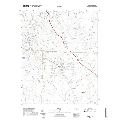
2020 Map of Landrum
USGS Topo · Published 2020About this map
Landrum and Columbus anchor this cross-border survey, which captures the complex topography where the foothills meet the Blue Ridge escarpment. The North Carolina-South Carolina state line bisects the map, passing through Mockingbird Hill and just north of Lake Lanier. The area is characterized by numerous small churchyards and burial grounds that define the local genealogy, including the Columbus Presbyterian Church Graveyard and Morgan Chapel Baptist Church Graveyard. Transport networks follow the river valleys and ridges, with the North Pacolet River and S Pacolet River providing the primary drainage. Notable crossings like Earle Bridge and Guthrie Bridge connect rural communities such as Ingleside and Campobello. The presence of the Fairview Airport and modern memorial sites like Polk Memorial Gardens reflects the ongoing development of this corridor between Spartanburg County and Polk County.
Find a feature on this map
57 named features on this map. Tap any name to fly to it.
Don’t see what you’re looking for? This feature index may not catch every label — zoom into the map to look around manually.
Map Details
Editions of this 2020 Landrum Map
This is the sole edition of this map. No revisions or reprints were ever made.
Other maps of this area

1907 · Saluda
USGS Topo · 1:125,000

1935 · Fishtop
USGS Topo · 1:24,000

1946 · Cliffield Mtn
USGS Topo · 1:24,000

1947 · Cliffield Mtn.
USGS Topo · 1:24,000

1955 · Knoxville
USGS Topo · 1:250,000

1957 · Knoxville
USGS Topo · 1:250,000

1959 · Lake Lure
USGS Topo · 1:62,500
1959 · Tigerville
USGS Topo · 1:62,500

1960 · Knoxville
USGS Topo · 1:250,000

1961 · Inman
USGS Topo · 1:62,500