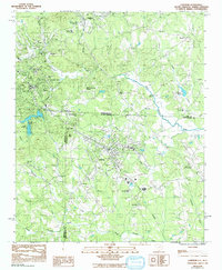
1968 Map of Landrum
USGS Topo · Published 1992About this map
The Southern RR railroad line serves as a central spine through this borderland region, connecting Tryon and Landrum across the North Carolina and South Carolina state line. This area is defined by the headwaters of the North Pacolet River and South Pacolet River, which carve through a landscape dotted with small communities and country institutions. Local genealogists will find significant value in the documentation of numerous burial grounds, including the Polk Mem Gardens near Columbus and the Evergreen Memorial Gardens further south. The map captures a mix of established residential pockets like Lynn and Ingleside alongside recreational and civic landmarks such as Lake Lanier, the Schiele Scout Res, and the South Carolina Welcome Center. From the Water Filtration Plant to the Fairview Airport, the infrastructure shown reflects the steady growth of these foothill towns during the late twentieth century.
Find a feature on this map
51 named features on this map. Tap any name to fly to it.
Don’t see what you’re looking for? This feature index may not catch every label — zoom into the map to look around manually.
Map Details
Editions of this 1968 Landrum Map
This is the sole edition of this map. No revisions or reprints were ever made.
Other maps of this area

1907 · Saluda
USGS Topo · 1:125,000

1935 · Fishtop
USGS Topo · 1:24,000

1946 · Cliffield Mtn
USGS Topo · 1:24,000

1947 · Cliffield Mtn.
USGS Topo · 1:24,000

1955 · Knoxville
USGS Topo · 1:250,000

1957 · Knoxville
USGS Topo · 1:250,000

1959 · Lake Lure
USGS Topo · 1:62,500
1959 · Tigerville
USGS Topo · 1:62,500

1960 · Knoxville
USGS Topo · 1:250,000

1961 · Inman
USGS Topo · 1:62,500