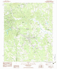
1983 Map of Landrum
USGS Topo · Published 1983About this map
The Southern railroad line anchors the development of Landrum and Tryon in this early 1980s survey of the Carolina foothills. Positioned along the state line where Polk Co meets Spartanburg Co, the area shows a transition from structured town grids to the winding paths of the Blue Ridge foothills. Local infrastructure is well-defined, from the Water Filtration Plant near Lake Lanier to the South Carolina Welcome Center situated along the primary highway corridor.
Find a feature on this map
50 named features on this map. Tap any name to fly to it.
Don’t see what you’re looking for? This feature index may not catch every label — zoom into the map to look around manually.
Map Details
Editions of this 1983 Landrum Map
This is the sole edition of this map. No revisions or reprints were ever made.
Other maps of this area

1907 · Saluda
USGS Topo · 1:125,000

1935 · Fishtop
USGS Topo · 1:24,000

1946 · Cliffield Mtn
USGS Topo · 1:24,000

1947 · Cliffield Mtn.
USGS Topo · 1:24,000

1955 · Knoxville
USGS Topo · 1:250,000

1957 · Knoxville
USGS Topo · 1:250,000

1959 · Lake Lure
USGS Topo · 1:62,500
1959 · Tigerville
USGS Topo · 1:62,500

1960 · Knoxville
USGS Topo · 1:250,000

1961 · Inman
USGS Topo · 1:62,500