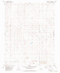
1982 Map of Landsman Hill
USGS Topo · Published 1982About this map
Landsman Hill rises above the drainage of the Smoky Hill River in this part of Cheyenne County, where the High Plains landscape is defined by long-distance resource management and livestock ranching. Surveyed in the mid-1970s and edited in 1982, the map documents a network of fine red dashed lines indicating property fence lines, which partition the open terrain between landmarks like Agate Mound. The scarcity of surface water is evident in the reliance on groundwater infrastructure, marked by numerous Wells and a central Water Tank that supported the agricultural operations of the era. The presence of isolated Tanks across the sections suggests a land use dedicated to cattle grazing, where specific topographic features and man-made water points were essential for navigating and managing the high prairie.
Find a feature on this map
7 named features on this map. Tap any name to fly to it.
Don’t see what you’re looking for? This feature index may not catch every label — zoom into the map to look around manually.
Map Details
Editions of this 1982 Landsman Hill Map
This is the sole edition of this map. No revisions or reprints were ever made.
Other maps of this area

1891 · Kit Carson
USGS Topo · 1:125,000

1892 · Cheyenne Wells
USGS Topo · 1:125,000

1893 · Kit Carson
USGS Topo · 1:125,000

1894 · Cheyenne Wells
USGS Topo · 1:125,000

1954 · Limon
USGS Topo · 1:250,000

1954 · Lamar
USGS Topo · 1:250,000

1957 · Limon
USGS Topo · 1:250,000

1958 · Limon
USGS Topo · 1:250,000

1958 · Lamar
USGS Topo · 1:250,000

1969 · Alpine Ranch
USGS Topo · 1:24,000