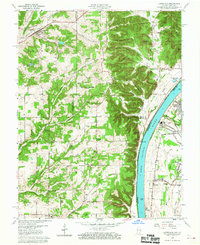
1960 Map of Lanesville
USGS Topo · Published 1961About this map
Lanesville serves as the focal point of this Harrison County survey, situated near the confluence of Indian Creek and Panther Creek. The landscape transitions from the upland ridges of Franklin and Posey townships toward the broad valley of the Ohio River. A high concentration of rural institutions suggests a well-established community fabric, with numerous cemeteries such as St Johns and Hopewell alongside country churches like Antioch Church. On the Kentucky side of the river, the suburban and industrial expansion of Jefferson County is evident in the developments of Riverside Gardens and Sylvania, where a Power Plant and Tank Farm stand near the Illinois Central railroad line. The topography is defined by prominent bluffs and points overlooking the river, including Hellmans Point and Vault Point, which overlook the navigable channel marked by river miles and the Locust Point landing.
Find a feature on this map
84 named features on this map. Tap any name to fly to it.
Don’t see what you’re looking for? This feature index may not catch every label — zoom into the map to look around manually.
Map Details
Editions of this 1960 Lanesville Map
2 editions found
Other maps of this area

1909 · Kosmosdale
USGS Topo · 1:48,000

1912 · Kosmosdale
USGS Topo · 1:62,500

1931 · Corydon
USGS Topo · 1:62,500

1939 · New Albany
USGS Topo · 1:24,000

1939 · Georgetown
USGS Topo · 1:24,000

1946 · New Albany
USGS Topo · 1:24,000

1947 · Georgetown
USGS Topo · 1:24,000

1948 · Corydon East
USGS Topo · 1:24,000

1948 · Laconia
USGS Topo · 1:24,000

1949 · Georgetown
USGS Topo · 1:24,000