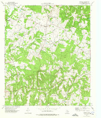
1973 Map of Laneville
USGS Topo · Published 1976About this map
The headwaters of the Angelina River define this rural landscape in southeastern Rusk County, where small agricultural settlements and family cemeteries are scattered across a complex network of creeks. Laneville serves as a central hub, surrounded by smaller communities such as Pirtle and Freeneytown. The terrain is shaped by the Elkins Mountains and Roberts Mountain, providing a varied topography that dictated the placement of early homesteads and road networks. Evidence of the region’s natural resource economy is visible through scattered Oil Well and Gas Well sites throughout the quadrangle.
Find a feature on this map
50 named features on this map. Tap any name to fly to it.
Don’t see what you’re looking for? This feature index may not catch every label — zoom into the map to look around manually.
Map Details
Editions of this 1973 Laneville Map
This is the sole edition of this map. No revisions or reprints were ever made.
Other maps of this area

1935 · Henderson
USGS Topo · 1:48,000

1939 · Henderson
USGS Topo · 1:62,500

1943 · Cushing
USGS Topo · 1:62,500

1945 · Cushing
USGS Topo · 1:62,500

1953 · Palestine
USGS Topo · 1:250,000

1956 · Tyler
USGS Topo · 1:250,000

1957 · Palestine
USGS Topo · 1:250,000

1960 · Minden
USGS Topo · 1:62,500

1960 · Mount Enterprise
USGS Topo · 1:62,500

1973 · Cushing
USGS Topo · 1:24,000