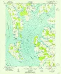
1954 Map of Langford Creek
USGS Topo · Published 1955About this map
The complex shoreline of the Chesapeake Bay's eastern shore is documented here during the mid-1950s, a period when the local landscape remained deeply tied to the water. The survey highlights Eastern Neck Island, a significant landmass separated by Grays Inn Creek and the narrow passage at Brown Narrows Pt. This area is characterized by an intricate network of coves and bights, such as Prussian Cove and Comegys Bight, which provided sheltered landings for the region's maritime economy.
Find a feature on this map
101 named features on this map. Tap any name to fly to it.
Don’t see what you’re looking for? This feature index may not catch every label — zoom into the map to look around manually.
Map Details
Editions of this 1954 Langford Creek Map
4 editions found
Other maps of this area

1892 · Annapolis
USGS Topo · 1:62,500

1893 · North Point
USGS Topo · 1:62,500

1898 · Choptank
USGS Topo · 1:125,000

1898 · Tolchester
USGS Topo · 1:125,000

1901 · Chestertown
USGS Topo · 1:62,500

1903 · Tolchester
USGS Topo · 1:125,000

1904 · St. Michaels
USGS Topo · 1:62,500

1904 · North Point
USGS Topo · 1:62,500

1904 · Annapolis
USGS Topo · 1:62,500

1908 · Tolchester
USGS Topo · 1:125,000