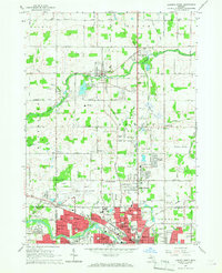
1965 Map of Lansing North
USGS Topo · Published 1967About this map
The Looking Glass River winds through the heart of this mid-1960s landscape, separating the developing suburban fringes of Lansing from the agricultural townships of DeWitt and Olive. This era shows a community in transition, where legacy farm infrastructure like the Simmons Sch and Hurd Cem sits adjacent to modern expansions like Clinton Village and the growing Capital City Airport.
Find a feature on this map
105 named features on this map. Tap any name to fly to it.
Don’t see what you’re looking for? This feature index may not catch every label — zoom into the map to look around manually.
Map Details
Editions of this 1965 Lansing North Map
3 editions found
Other maps of this area

1909 · Mason
USGS Topo · 1:62,500

1910 · Lansing
USGS Topo · 1:62,500

1911 · Mason
USGS Topo · 1:62,500

1912 · Lansing
USGS Topo · 1:62,500

1927 · De Witt
USGS Topo · 1:62,500

1928 · Laingsburg
USGS Topo · 1:62,500

1944 · Laingsburg
USGS Topo · 1:62,500

1958 · Grand Rapids
USGS Topo · 1:250,000

1961 · Grand Rapids
USGS Topo · 1:250,000

1962 · Grand Rapids
USGS Topo · 1:250,000