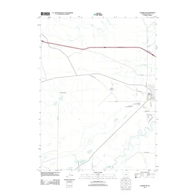
2012 Map of Laramie SW
USGS Topo · Published 2012About this map
West Laramie and the surrounding high plains of Albany County are defined by a sophisticated network of irrigation and academic research. The landscape is marked by the Pioneer Canal, Park Ditch, and Pioneer Lateral, which channel water across the arid terrain near The Big Hollow. Educational and agricultural history is anchored here by the University of Wyoming Agronomy Farm and the University of Wyoming Dairy Farm, positioned southwest of the Laramie Regional Airport. Along the meandering course of the Laramie River, smaller settlements and landings like River Ranch appear alongside natural features such as Fivemile Cr and Sevenmile Lakes. The transition from the residential streets of West Laramie to the expansive open ranges illustrates the region's dual identity as both a university hub and a ranching center.
Find a feature on this map
29 named features on this map. Tap any name to fly to it.
Don’t see what you’re looking for? This feature index may not catch every label — zoom into the map to look around manually.
Map Details
Editions of this 2012 Laramie SW Map
This is the sole edition of this map. No revisions or reprints were ever made.
Other maps of this area

1895 · Laramie
USGS Topo · 1:125,000

1902 · Laramie
USGS Topo · 1:125,000

1905 · Laramie
USGS Topo · 1:125,000

1906 · Laramie
USGS Topo · 1:125,000

1908 · Laramie
USGS Topo · 1:125,000

1954 · Cheyenne
USGS Topo · 1:250,000

1958 · Cheyenne
USGS Topo · 1:250,000
1962 · Miller
USGS Topo · 1:24,000
1963 · Laramie
USGS Topo · 1:24,000
1963 · Caldwell Lake
USGS Topo · 1:24,000