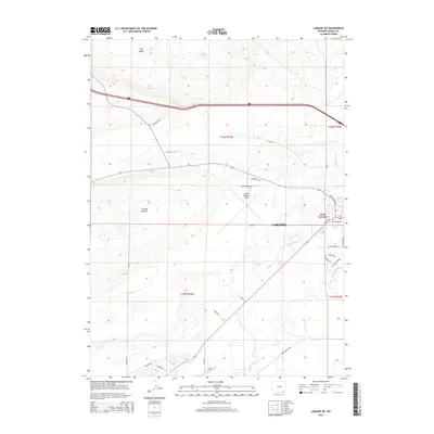
2015 Map of Laramie SW
USGS Topo · Published 2015About this map
West Laramie and the Laramie Regional Airport anchor the eastern edge of this high plains landscape, where the urban fringe of Laramie meets the open ranching country of Albany County. The region is defined by a sophisticated network of irrigation and water management, necessary for the arid Wyoming climate. The Pioneer Canal, Pioneer Lateral, and Park Ditch snake across the terrain, redirecting water toward agricultural lands and the Sevenmile Lakes. To the west, the massive depression of The Big Hollow sits near Big Basin, illustrating the unique wind-eroded geology of the Laramie Plains.
Find a feature on this map
39 named features on this map. Tap any name to fly to it.
Don’t see what you’re looking for? This feature index may not catch every label — zoom into the map to look around manually.
Map Details
Editions of this 2015 Laramie SW Map
This is the sole edition of this map. No revisions or reprints were ever made.
Other maps of this area

1895 · Laramie
USGS Topo · 1:125,000

1902 · Laramie
USGS Topo · 1:125,000

1905 · Laramie
USGS Topo · 1:125,000

1906 · Laramie
USGS Topo · 1:125,000

1908 · Laramie
USGS Topo · 1:125,000

1954 · Cheyenne
USGS Topo · 1:250,000

1958 · Cheyenne
USGS Topo · 1:250,000
1962 · Miller
USGS Topo · 1:24,000
1963 · Laramie
USGS Topo · 1:24,000
1963 · Caldwell Lake
USGS Topo · 1:24,000