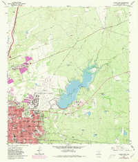
1965 Map of Laredo East
USGS Topo · Published 1980About this map
Laredo expands eastward toward the waters of Lake Casa Blanca in this 1960s survey, updated with 1970s urban growth data. The landscape transitions from a dense urban grid to open brushland and essential infrastructure, including the sprawling Laredo International Airport and its accompanying Airway Beacon. Local history is deeply etched into the street names and institutional landmarks, from the established grounds of the Catholic Cem and City Cem to the long-standing educational presence of St Joseph Academy and Ursuline Academy.
Find a feature on this map
67 named features on this map. Tap any name to fly to it.
Don’t see what you’re looking for? This feature index may not catch every label — zoom into the map to look around manually.
Map Details
Editions of this 1965 Laredo East Map
2 editions found
Other maps of this area

1933 · Becerra Creek
USGS Topo · 1:62,500

1956 · Islitas
USGS Topo · 1:62,500

1956 · Laredo East
USGS Topo · 1:62,500

1956 · Laredo
USGS Topo · 1:250,000

1965 · Laredo West
USGS Topo · 1:24,000

1965 · Orvil
USGS Topo · 1:24,000

1965 · Cuervo Creek
USGS Topo · 1:24,000

1965 · Cibolo Ranch
USGS Topo · 1:24,000

1965 · Tios Creek
USGS Topo · 1:24,000

1965 · Laredo East
USGS Topo · 1:24,000