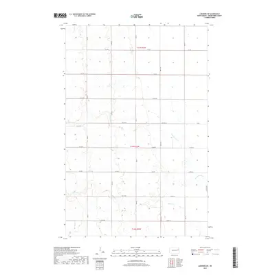
2018 Map of Larimore SW
USGS Topo · Published 2018About this map
The Little Goose River and Goose River wind through this prairie landscape in Grand Forks County, defining the drainage patterns of the eastern Dakotas. This late-2010s survey illustrates a rural grid dominated by section lines and local transit routes such as Co Rd 20 and Co Rd 6. The terrain is marked by the subtle incision of Spring Cr in the southwest corner and the meandering path of the river systems, which historically provided essential water sources for the homesteads and farms that carved out this agricultural region. The map provides a contemporary view of the surveyed townships of t151n r55w, t150n r55w, and t149n r55w, preserving the names of the secondary roads and avenues that connect these isolated rural communities.
Find a feature on this map
21 named features on this map. Tap any name to fly to it.
Don’t see what you’re looking for? This feature index may not catch every label — zoom into the map to look around manually.
Map Details
Editions of this 2018 Larimore SW Map
This is the sole edition of this map. No revisions or reprints were ever made.
Other maps of this area

1936 · Larimore
USGS Topo · 1:62,500

1939 · Niagara
USGS Topo · 1:62,500

1952 · Grand Forks
USGS Topo · 1:250,000

1956 · Grand Forks
USGS Topo · 1:250,000

1963 · Larimore East
USGS Topo · 1:24,000

1963 · Kempton
USGS Topo · 1:24,000

1963 · Larimore SW
USGS Topo · 1:24,000

1963 · Larimore West
USGS Topo · 1:24,000
1963 · Niagara
USGS Topo · 1:24,000

1963 · Logan Center
USGS Topo · 1:24,000