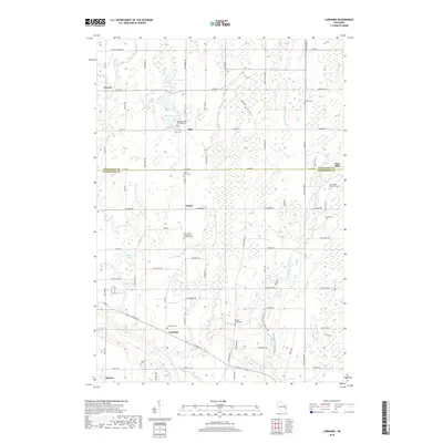
2018 Map of Larrabee
USGS Topo · Published 2018About this map
The West Twin River and East Twin River define the agricultural landscape of this region straddling the border of Kewaunee and Manitowoc counties. Small farming communities such as Larrabee, Bolt, and Zander are connected by a grid of county roads and local routes like Nuclear Rd and Sleepy Hollow Rd. The map reveals a dense distribution of local heritage sites, including the Bolt Bohemian Township Cem and Saint Mary Catholic Cem, reflecting the area's ancestral settlement patterns. Numerous small water bodies, such as Harpt Lake, Shea Lake, and Heidmann Lake, are scattered throughout the glacial terrain, often found near family-named landmarks and rural intersections. This recent survey shows the persistent rural character of the Wisconsin lakeshore hinterland, where the proximity to Lake Michigan is felt through drainage patterns like Tisch Mills Cr and Jambo Cr.
Find a feature on this map
87 named features on this map. Tap any name to fly to it.
Don’t see what you’re looking for? This feature index may not catch every label — zoom into the map to look around manually.
Map Details
Editions of this 2018 Larrabee Map
This is the sole edition of this map. No revisions or reprints were ever made.
Other maps of this area

1954 · Kewaunee
USGS Topo · 1:62,500

1954 · Manitowoc
USGS Topo · 1:62,500

1954 · Denmark
USGS Topo · 1:62,500

1954 · Reedsville
USGS Topo · 1:62,500

1954 · Manitowoc
USGS Topo · 1:250,000

1958 · Manitowoc
USGS Topo · 1:250,000

1978 · Denmark
USGS Topo · 1:24,000
1978 · Two Rivers
USGS Topo · 1:24,000

1978 · Poland
USGS Topo · 1:24,000

1978 · Stangelville
USGS Topo · 1:24,000