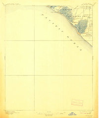
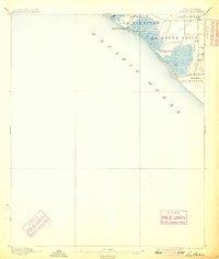
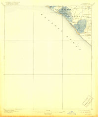
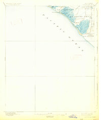
1896 Map of Las Bolsas
USGS Topo · Published 1908About this map
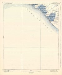
Anaheim Landing serves as the primary coastal point of reference on this late 19th-century survey of the Orange County shoreline. The landscape is defined by the expansive wetlands and marshes of Bolsa Chica and the surrounding ranchos, including Los Alamitos, La Bolsa Chica, and Las Bolsas. These Spanish-named land grants reflect the transitional period of Southern California's development, where vast coastal plains were beginning to see the introduction of artificial waterways like the marked Ditch and Drainage systems. Waterways such as Anaheim Creek and Bolsas Creek meander through the low-lying terrain toward the Pacific Ocean, while Landing Hill provides a rare point of elevation along the coast. The map also captures the inland boundary between Los Angeles and Orange Counties during the first decade of Orange County's existence as a separate entity.
Find a feature on this map
13 named features on this map. Tap any name to fly to it.
Don’t see what you’re looking for? This feature index may not catch every label — zoom into the map to look around manually.
Map Details
Editions of this 1896 Las Bolsas Map
6 editions found
Other maps of this area

1896 · Santa Ana
USGS Topo · 1:62,500

1896 · Anaheim
USGS Topo · 1:62,500

1896 · Redondo
USGS Topo · 1:62,500

1896 · Las Bolsas
USGS Topo · 1:62,500

1896 · San Pedro
USGS Topo · 1:62,500

1896 · Downey
USGS Topo · 1:62,500

1898 · Anaheim
USGS Topo · 1:62,500

1899 · Downey
USGS Topo · 1:62,500

1901 · Southern California Sheet No. 1
USGS Topo · 1:250,000

1901 · Santa Ana
USGS Topo · 1:62,500